Satellite Captures Vibrant Submerged Landscapes on Great Bahama Bank
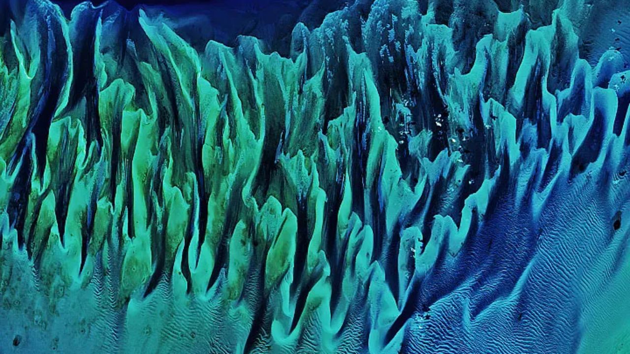
A striking satellite image captured by Landsat 8 on February 15, 2020, has unveiled a captivating display of natural artistry across the Great Bahama Bank. The photograph showcases intricate, 'painting-like' ripples formed by submerged sandbanks and extensive seagrass beds in the shallow waters of the Bahamas, offering an ethereal perspective of an ancient seafloor.
These vibrant patterns, observed from space, are a testament to the dynamic interplay of natural forces that continuously sculpt the underwater topography of the region. Ocean currents, tides, and the movement of sediment work in concert to create ever-shifting landscapes beneath the surface, revealing a complex and beautiful environment.
The Great Bahama Bank is a vast underwater carbonate platform, one of the largest in the world, characterized by its exceptionally shallow waters. This expansive geological feature is not only a marvel of natural formation but also a critical component of the local marine ecosystem, supporting diverse life forms, including the crucial seagrass meadows depicted in the image.
Images such as this, originally reported by LiveScience, offer more than just aesthetic appeal. They provide invaluable data for scientists and researchers. By continuously monitoring these marine environments, experts can track changes in the distribution of sand and seagrass, assess the health of these vital habitats, and gain deeper insights into sediment transport processes over time.
The Landsat program, a joint initiative by NASA and the U.S. Geological Survey (USGS), has been a cornerstone of Earth observation for decades. Landsat 8, launched in 2013, continues this legacy, providing high-resolution imagery that is instrumental in understanding environmental changes across the globe, from terrestrial landscapes to coastal and shallow-water marine areas.
The detailed views of these shallow-water systems are particularly important for environmental monitoring. They help inform conservation strategies, coastal management plans, and efforts to understand the impact of natural phenomena and human activity on these delicate ecosystems. The ability to observe such intricate details from orbit highlights the power of remote sensing technology.
Ultimately, the satellite's lens not only reveals the profound beauty of our planet's often-hidden marine landscapes but also underscores the critical need for ongoing observation and scientific study. Such visual records contribute significantly to our collective knowledge, helping to safeguard these vital natural resources for future generations.


Comments (0)
Be the first to comment.
Join the discussion