From Orbit: Europe's Landscapes Bear Scars of Extreme Summer Heat and Drought
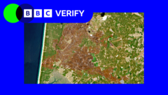
Western Europe's vital natural landscapes, from its meandering rivers to its vast agricultural fields and towering mountain ranges, have visibly succumbed to the intense pressures of recent summer heatwaves and prolonged drought. An examination by BBC Verify, building on reports from BBC Science, has utilized satellite imagery to highlight the dramatic and widespread environmental impact, revealing a continent grappling with unprecedented climatic stress.
The view from space offers a stark perspective on the severity of the conditions. What were once vibrant green valleys and flowing waterways now appear parched and diminished. Major rivers, crucial for transport, irrigation, and ecosystems, show significantly reduced water levels, with exposed riverbeds becoming a common sight in many regions. This depletion affects not only aquatic life but also the availability of freshwater for human consumption and economic activities.
Agricultural lands across the continent have also borne the brunt of the exceptional heat and lack of rainfall. Fields that would typically be lush with crops are instead characterized by withered vegetation and cracked earth. This widespread crop stress poses significant concerns for food security and the livelihoods of farmers, contributing to potential economic instability in affected areas as yields decline.
Even Europe's mountainous regions, often perceived as more resilient, display clear signs of environmental distress. Vegetation on slopes appears stressed and desiccated, increasing the risk of wildfires, which have ravaged parts of the continent in recent years. The long-term implications for unique alpine ecosystems and local biodiversity are profound, indicating a shift in natural patterns driven by warming trends.
The comprehensive analysis by BBC Verify underscores the critical role of satellite observation in documenting large-scale environmental changes. These remote sensing capabilities provide invaluable data, allowing scientists and policymakers to assess the extent of the damage, monitor ongoing developments, and understand the broader implications of such extreme weather events on a continental scale.
This visual evidence serves as a powerful reminder of the escalating frequency and intensity of extreme weather phenomena impacting Europe. While seasonal variations are natural, the scale and consistency of these recent events align with projections concerning a changing global climate, prompting urgent discussions about long-term adaptation and mitigation strategies.
As independent publications continue to report on these shifts, the satellite-derived insights offer an undeniable record of Europe's transforming environment. The scorched landscapes captured from orbit are not merely visual curiosities; they are tangible indicators of a profound ecological challenge that demands sustained attention and concerted action from governments, communities, and scientific bodies alike.


Comments (0)
Be the first to comment.
Join the discussion